A continuation of yesterpost...
My tour of Hoover Dam started with a short film about the building of the dam. Then I went down an elevator into the dam. The first part of the tour starts in the tunnels dug to divert the Colorado River around the dam site.
A picture shows the only time that the dam was flooded, with water going over the top of the dam in the 1980s. Even with so much extra water, the dam held.
The tour took us to the line of generators on the Nevada side of the dam. The small generator in the lower right below provides electricity for the dam's facilities.
Many of the halls were built with marble and decorations inspired by the project and imitating the Native American art from local tribes. The below symbol shows the strength of the waters. Art Deco was still popular in the 1930s, so the builders had that influence as well.
Some of the halls are much more plain and meant only for workers to see.
Even those halls have occasional decorations. The drainage grates were eventually filled in since women's high-heeled shoes would get caught in the holes.
One of the best parts of the tour is getting to go down a side hall and see one of the "windows" in the face of the dam. The openings provide ventilation for the dam's interior hallways. The tour guide said that in the summer, that ventilation is less than desirable with 100 degree Fahrenheit air coming in.
The circular hall has an access tunnel that goes straight down. I was a little reluctant to step on the grating even though it was clearly secure and safe.
The work halls let the employees inspect the dam for cracks or other faults. Most of the cracks that happened were in the first few years as the concrete cured and the dam settled.
A system was developed to mark what part of the hall a worker found cracks or other items that needed attention.
The dam has earthquake sensors just in case a catastrophic event were to happen. The dam is supposed to withstand mild earthquakes. We were forbidden from touching the sensors.
Just in case the elevators don't work, a set of stairs was installed. They are very steep and have some platforms at certain levels for those who get weary from climbing. The bottom of the stairs is sometimes in water!
The concrete blocks were given letters to designate where they changed (and so people wouldn't think a large crack had formed!).
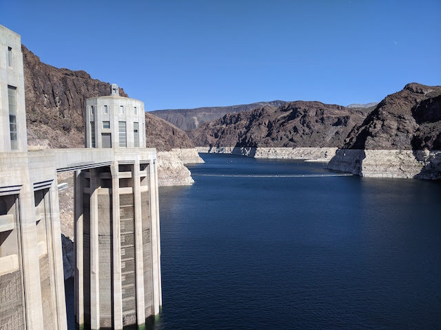
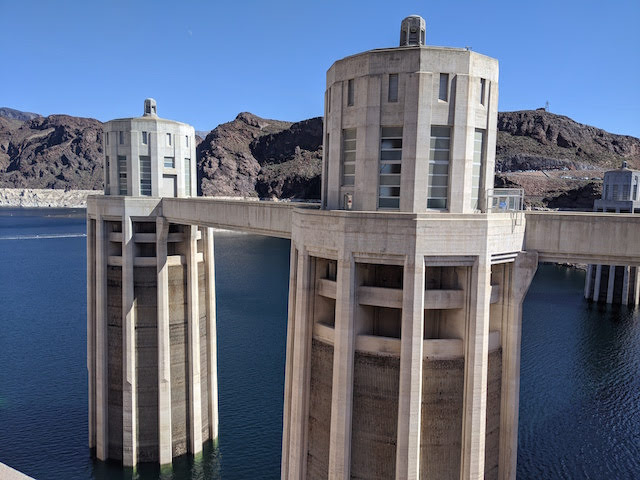
The tour ends at the top of the dam with a view of the the intake towers.
The top of the dam looks down on the river and power generators far below. It gave me the willies!
The view back to the parking lot is less stressful.
The dam creates Lake Mead. When I visited, the water was about sixty feet below where they wanted it. Even so, there is still plenty of water and no worry for power or irrigation.
The dam has a small building on top of the elevator into the dam.
The river is the border between Nevada and Arizona. It's also the line between the Pacific and Mountain Time Zones. A plaque shows the spot so visitors can be in two states and two time zones at the same time.
The intake towers provide the water that goes to the turbines on the other side of the dam. Tourists don't get to visit the towers.
A plaque commemorates Doctor Elwood Mead for whom the lake is named. He was a water and irrigation engineer who worked on the dam project. He died in 1936 so Hoover Dam was his last great project.
Another display commemorates those who died during the construction of the dam. The tour guide said that no one is buried in the dam, contrary to popular belief.
Nearby is a commemoration of completion of the project. Two angels overlook a display showing where the stars and planets were in the sky when they dedicated the project in 1935. That way if future people or aliens (the outer space kind) visit they can calculate when the dam was built. It struck me as a bit egotistical.
The various states involved in the project are also part of the Colorado River system.
The Hoover Dam is an amazing achievement and a spectacular site to visit.
My tour of Hoover Dam started with a short film about the building of the dam. Then I went down an elevator into the dam. The first part of the tour starts in the tunnels dug to divert the Colorado River around the dam site.
 |
| Transition from cliff rock to dam concrete |
 |
| More of the tunnel |
 |
| Another view |
A picture shows the only time that the dam was flooded, with water going over the top of the dam in the 1980s. Even with so much extra water, the dam held.
 |
| The dam disappearing |
 |
| Diagram of the dam and the flow of water |
The tour took us to the line of generators on the Nevada side of the dam. The small generator in the lower right below provides electricity for the dam's facilities.
 |
| The Nevada generators |
 |
| The dam's power is produced with a smaller generator--self-sufficiency! |
Many of the halls were built with marble and decorations inspired by the project and imitating the Native American art from local tribes. The below symbol shows the strength of the waters. Art Deco was still popular in the 1930s, so the builders had that influence as well.
 |
| In the floor |
Some of the halls are much more plain and meant only for workers to see.
 |
| Maintenance hall |
Even those halls have occasional decorations. The drainage grates were eventually filled in since women's high-heeled shoes would get caught in the holes.
 |
| Drain that doesn't drain |
One of the best parts of the tour is getting to go down a side hall and see one of the "windows" in the face of the dam. The openings provide ventilation for the dam's interior hallways. The tour guide said that in the summer, that ventilation is less than desirable with 100 degree Fahrenheit air coming in.
 |
| A small, circular hall |
 |
| The "window" |
 |
| View from the window |
The circular hall has an access tunnel that goes straight down. I was a little reluctant to step on the grating even though it was clearly secure and safe.
 |
| Access going down |
The work halls let the employees inspect the dam for cracks or other faults. Most of the cracks that happened were in the first few years as the concrete cured and the dam settled.
 |
| Inspection hall |
 |
| An old-style phone |
A system was developed to mark what part of the hall a worker found cracks or other items that needed attention.
 |
| 40 feet from 0 |
 |
| A crack found in 1934 that didn't get bigger |
The dam has earthquake sensors just in case a catastrophic event were to happen. The dam is supposed to withstand mild earthquakes. We were forbidden from touching the sensors.
 |
| Earthquake detectors |
Just in case the elevators don't work, a set of stairs was installed. They are very steep and have some platforms at certain levels for those who get weary from climbing. The bottom of the stairs is sometimes in water!
 |
| The stairs going down |
 |
| The stairs going up |
The concrete blocks were given letters to designate where they changed (and so people wouldn't think a large crack had formed!).
 |
| Meeting of Q and P blocks |
The tour ends at the top of the dam with a view of the the intake towers.
 |
| One of the intake towers |
The top of the dam looks down on the river and power generators far below. It gave me the willies!
 |
| The river below |
 |
| View of the river and bridge |
The view back to the parking lot is less stressful.
 |
| The Nevada side of the dam |
The dam creates Lake Mead. When I visited, the water was about sixty feet below where they wanted it. Even so, there is still plenty of water and no worry for power or irrigation.
 |
| Lake Mead |
The dam has a small building on top of the elevator into the dam.
 |
| Near the middle of the bridge |
The river is the border between Nevada and Arizona. It's also the line between the Pacific and Mountain Time Zones. A plaque shows the spot so visitors can be in two states and two time zones at the same time.
 |
| Plaque commemorating the project |
 |
| Blogger on both sides of the line |
 |
| The lake at a lower state |
The intake towers provide the water that goes to the turbines on the other side of the dam. Tourists don't get to visit the towers.
 |
| Intake towers |
 |
| The back of the dam |
A plaque commemorates Doctor Elwood Mead for whom the lake is named. He was a water and irrigation engineer who worked on the dam project. He died in 1936 so Hoover Dam was his last great project.
 |
| Dr. Mead |
Another display commemorates those who died during the construction of the dam. The tour guide said that no one is buried in the dam, contrary to popular belief.
 |
| Memorial to those who died on the project |
Nearby is a commemoration of completion of the project. Two angels overlook a display showing where the stars and planets were in the sky when they dedicated the project in 1935. That way if future people or aliens (the outer space kind) visit they can calculate when the dam was built. It struck me as a bit egotistical.
 |
| Angels overlooking the dam |
 |
| Part of the star chart |
 |
| The base of the memorial |
The various states involved in the project are also part of the Colorado River system.
 |
| Arizona, Nevada... |
 |
| ...New Mexico, Wyoming, Colorado... |
 |
| ...California, and Utah |
The Hoover Dam is an amazing achievement and a spectacular site to visit.


